From Gua Ikan we headed back to Jelawang. By the time we crossed the bridge over the river Galas the fog which has obscured much of the area has subsided allowing us to see the mountains behind. Look closely to the left, you should be able to see a giant waterfall on the side of a mountain.
 Further down the road I snapped another picture of the mountains. The waterfall should be clear enough...
 Another picture taken further down the road. If you can't see where the waterfall is perhaps and appointment with an eye specialist is in order...
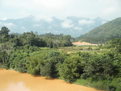
 Close to Jelawang it is very obvious.
 Zooming in. Every local know the waterfall which is called the Jelawang waterfall of Gunung (mount) Stong. It is a sight they savour every second of the day... if it's not foggy that is.
 This is a view from the Gua Musang junction.
 Zooming in again. This waterfall has been touted as the tallest in South East Asia. I've checked with Google Earth and found its top part to be almost 1,600 feet above sea level!
 Just a short distance from the junction is the entry road towards the fall.
 We took it. Here's the view from the highest part of the road.
 Getting closer...
 There's a resort at the foot of Gunung Stong, the mountain where lies the route up to the waterfall.
 This is one of the pools formed from the waters down the waterfall.
 From here it takes at least half and hour to climb up. Not only it is tiring, we haven't got the time. So here's a last look before we head somewhere else.
 Soon we arrived at the small town of Jeli.
 The town is situated about 10 km from the bridge over Sungai Pergau.
 Frankly I found there is not much to look at in Jeli. But being the closest Kelantan town to the state of Perak it has a significant position in geography...
 Whatever, I always like to snap pictures for posterity and what is available here should give a fair view of the small town.


 From the foot of Gunung or Mount Stong we headed by some 15 km towards Gua Musang to check out another waterfall (or rather, waterfalls).