Thursday, September 15, 2011

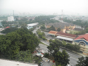
Views from Kuala Lumpur's Batu high-rise flats

On to something done the recent Monday.


After having breakfast at the wet market of Batu, Kuala Lumpur I returned to the car parked at the nearby high-rise flats when a thought occured...

Why not go up to the top floor and snap pictures of the views?


So there I was at the 17th floor looking out this opening.


I believe this is headed west.


Going to what I surmise must be the southern part of the flats this is the view available.


Turning slightly to the left I could see the KL centre in the background amidst the haze plaguing parts of the Peninsular the last few days.


Then it's time to go to the northern part where you could see the limestone hill of Batu Caves.


Looking down to the right I could see the market where I had breakfast at.


A look to the left.


And further left. Enough...


Tomb of Panglima Pidi revisited

Continued from The new look of Sultan Alauddin of Melaka's tomb.


Next we went to the city of Melaka aiming straight for the hill called Bukit Cina.


Bukit is the Malay word for hill and Bukit Cina means hill of the Chinese. So it is only natural if it's full of Chinese cemeteries.


But yet at one peak (I understand the hill has 2 peaks) you can find Malay Muslim cemeteries.


The most prominent are this two outstandingly long tombs.


It is understood that one of the long tombs belong to a person known as Panglima Pidi, a general who came from the region of Pidi in Aceh. He was one of the commanders in the 1629 AD Acehness attack against the Portuguese forces occupying the city of Melaka and became a casualty.


Wednesday, September 14, 2011

The new look of Sultan Alauddin of Melaka's tomb


Next we went to Kampung Raja, Pagoh where lies the tomb of ruler of Melaka known as Sultan Alauddin Riayat Shah (ruled 1477-1488 AD).


The last time we paid visit was about half a year ago.


This time we noticed a very good change.


The inscriptions on the tombs made in the Arabic language and writing have been coloured gold making it easier to read and recognise.


Please refer and compare with the pictures shown in the article Batu-batu nesan di makam Sultan Alauddin Melaka (Tombstones at the tomb of Sultan Alauddin of Melaka) made in the blogspot SENI LAMA MELAYU (MALAY OLDEN ART) 5 months ago.


The 4 tombstone and each 2 faces and 2 sides of every tombstone are presented here exactly in the same order as in the old article for easy reference.


Note: 3 am 19 September 2011. I've just noticed I've only put pictures from 3 tombstones instead of 4 as it should be. So below are the pictures from the 4th tombstone ya. Cheers! :]


Views from the mosque tower of Simpang Baba

On to last weekend when I returned to the place I grew up at, Muar to attend a function. The following day Sunday I started a small trip by heading towards Pagoh.


As I passed by Simpang Baba not far from my mum's native village, Kampung Temiang I felt like visiting its mosque and climbing up its tower.


As there is no tall building within miles around here the tower offers a vantage look at things. The tower has five sides so I started taking pictures counter clockwise.


And finally before I went down. A look showing the tower's actual function. For calling people to come and pray...


Looking for a certain valley besides the LATAR highway

Almost 2 months ago I did a piece called A look at the newly-opened LATAR highway and showed pictures of a valley where lies what looked like a fishing pond. Last week I finally decided to look for the access road to the said valley. So here's the small story.


Looking at the Google Earth map and from my wife's understanding of Rawang town geography the access road to the said valley should be near an urban area on the southen outskirts of town.


By trial and error I decided to take a small village road and started to see a pond.

And the road leads to an underpass under the LATAR highway. But the area didn't fit the bill of the valley we're looking for.


As it turned out we've missed a turn which should have been easier to find as it has a signboard pointing to a fishing pond.


It leads to a gravel strewn road...


Ah. The fishing pond.


Yes. This one fits the bill.


We even took the underpass here.


Now I felt satisfied having checked out the area as far as I could. For the record this is the 858th posting in this blogspot.