Continued from The
Mossy Forest of Cameron Highlands.
Soon I arrived at the summit of Mount Brinchang.
However most of the summit area is off-limits as it houses a telecommunications centre.
But you can follow a foot-path around it.
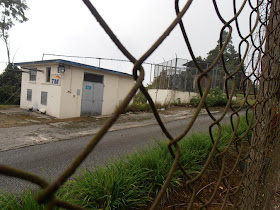
Going anti-clockwise I found the foot-path going up albeit not so steep.
It leads to this corner.
Then it practically goes down.
Upon reaching the next corner I could definitely surmiss the previous corner is higher.
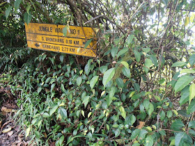
The signboard here puts things to perspective. The marking "G. Brinchang 0.19 km" means that the proper summit and highest point of the mountain is 190 metres away. "Brinchang 2.77 km" in turn refers to the distance to the entrance of the jungle mountain climbing path close to town. Look at the article A
morning look at the town of Brinchang.
The distance 2.77 km is by foot climbing up through the jungle path. By motor vehicles you must travel 4 km to get to the right junction before climbing up another 7 km by a small road to reach the summit. Look at The
road up Mount Brinchang.
I followed the perimeter fencing again to complete a round.
The next corner is situated even lower.
Soon I could see where I started, in front of the gates of the fenced area. Having completed a round it looks to me that the corner first mentioned in this article is the highest point around the perimeter. But the distance of 190 metres from the signboard at the next corner seems to indicate the actual summit elsewhere. Never mind. The time I spent around walking at every high ground in sight should cover that...


No comments:
Post a Comment