Tuesday, October 16, 2012

Terengganu river from Kuala Berang bridge

Continued from Terengganu river at Jenagor.


Still on the river Terengganu, I decided to savour views from another interesting place.


This is from the bridge crossing the river on to the nearby town of Kuala Berang.


For the record Kuala Berang means the estuary  (kuala) of the Berang river. This is because the area is close to the place where the Berang river flows into the Terengganu river.


The left is the Berang river. In the middle of the picture is its estuary.


Time to look downriver. 


Terengganu river at Jenagor


Going 2-3 kilometres downriver or so we arrived at this jetty.


The area is called Jenagor.


The jetty is used to get to get to a certain settlement upriver.


A look down the Terengganu river.


Here's a view from the boat as we go against the flow to reach the said settlement.


Soon you can see the Batu Belah, a split stone said to have made that way after a bare-handed chop by a saintly person.


And afterwards you can see the settlement.


Terengganu river near its main dam

Continued from Pengkalan Gawi... again.


Next we wanted to enter the main dam which creates the vast man-made lake called Tasik (lake of) Kenyir.


I have entered the dam area once or twice. Too bad it has been turned into a restricted area. So we tried to find another alternative.


We have to go down the slopes to get close to the river.


It is the Terengganu river, the main and biggest river of the state which carries the same name.


Here we are looking at an uppermost part of the river.


From here we can see the dam.


For the record Lake Kenyir was created by this dam and a few smaller dams controlling and containing the flow of the Terengganu rivers and a number of its tributaries.


A look across.


A look downriver.


To have a better look we walked to this part.


There. You can see the river flows down to the horizon.


Pengkalan Gawi... again

Continued from Lake Kenyir at Sungai Lawit.


Next came the most well-known part of Lake Kenyir, at an area called Pengkalan Gawi.


It is so well-known that when most people say they went to Lake Kenyir, they are actually referring to this part.


Pengkalan Gawi simply means the base of Gawi and for most people especially tourists and anglers, this is the starting point to explore the vast lake.


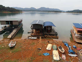
Do notice how much the water level has dropped.


For the record this is the first part of Lake Kenyir I have ever visited starting in 1997 or so.


Since then I have visited Pengkalan Gawi 2-3 times excluding this visit. That should explain the title "Pengkalan Gawi... again".


Lake Kenyir at Sungai Lawit


Next we went to a section of Lake Kenyir beside a place called Sungai (river of) Lawit.


It seems there was plenty of undergoing work then.


Ahead in the background lies the most well-known part of Lake Kenyir.


For the record Lake Kenyir is bigger that the state island of Singapore. So there are certainly many many parts and viewing points.


Northern end of Terengganu river which flows into Lake Kenyir


Heading further west we soon passed the rest area we spend the night at and on to what looked like a tapering part of Lake Kenyir.


However a close study of the map shows this is actually an upper part of the Terengganu river flowing to create the lake. Here is a look upriver.


Now for a look downriver.


Interesting how the bridge curves as it crossed the river.


Lake Kenyir and its vast waters should lie after this river turn... or maybe further away, I don't know.


A look down.


A look to the left.