-----------------------

This blogspot is a medium to share my thoughts and adventures apart from promoting my books. Below are the books which have been written or authored and published by myself.


"Berpetualang ke Aceh: Mencari Diri dan Erti".

ISBN 983-42031-0-1, Jun 2006


"Berpetualang ke Aceh: Membela Syiar yang Asal"

ISBN 983-42031-1-x, May 2007


"Berpetualang ke Aceh: Sirih Pulang ke Gagang?"

ISBN 978-983-42031-2-2, November 2007


It is interesting to note that while these books were written in Malay it has gained enough attention to merit being part of the collections of the American Library of Congress and National Library of Australia. Look here and here.


While the first three books were published by my own company, the fourth titled "Rumah Azan" was published in April 2009 by a company called Karnadya with the help of the Malaysian national literary body Dewan Bahasa dan Pustaka. It features beautiful pictures along with stories behind selected mosques which could be related to the history of Islam and the Malays alongside the formation of the Malaysian nation. Look at the article A collaboration of old collegemates - the book "Rumah Azan".


My fifth book "Ahlul Bait (Family) of Rasulullah SAW and Malay Sultanates", an English translation and adaptation of the Malay book "Ahlul Bait (Keluarga) Rasulullah SAW dan Kesultanan Melayu" authored by Hj Muzaffar Mohamad and Tun Suzana Othman was published early 2010. Look here... My 5th book is out! Ahlul Bait (Family) of Rasulullah SAW and the Malay Sultanates... . For more information check out my Malay blogspot CATATAN SI MERAH SILU.


Like my fourth book "Rumah Azan", the sixth book "Kereta Api Menuju Destinasi" is also a coffee-table book which is published by the company Karnadya with the cooperation of Dewan Bahasa dan Pustaka (the main Malay literary body in Malaysia). Coming out January 2011 it features pictures and stories on the adventure travelling by train to all of Peninsular Malaysia along with the interesting places which could be reached this way.


My seventh book "Jejak keluarga Yakin : Satu sketsa sejarah" in turn is a coffee-table book which is written, editted, designed and has pictures taken by me. Coming out of the factory October 2011, this book which combines family history with history of places such as Singapura, Johor, Batu Pahat, Muar and in fact the history of the island of Java and England has been reviewed with me interviewed live in the program Selamat Pagi Malaysia at RTM1. Look at the article Siaran langsung ulasan buku "Jejak keluarga Yakin : Satu sketsa sejarah" dan temu ramah di Selamat Pagi Malaysia. Some selected contents have been featured in Sneak peek "Jejak keluarga Yakin : Satu sketsa sejarah".


-----------------------


The "Berpetualang ke Aceh" series of novels could be obtained in e-book form. Enter http://www.e-sentral.com/, click general novel and go to page 4. You can also type the word "Aceh" at the search box. Or click straight Book 1, Book 2 and Book 3.


Saturday, January 12, 2008

A quaint look at the town of Pontian

Yep... That's what the title says. This article is practically a continuation of the Malay article Mencari Muzium Bugis di Pontian... (looking for the Bugis museum in Pontian) made in the blogspot CATATAN SI MERAH SILU just now...


This is a picture taken from the cheap hotel where I lodged at in Pontian some 3 weeks ago. I felt like looking out the window and thought this a rather interesting angle and look at things....


A look at rooftop level heading towards the east shows Gunung (mount) Pulai in the backdrop. At 2,000 feet-plus high, it is the only prominent peak within the proximity of the city of Johor Bahru.

Notice the many high aerials in the picture? In some parts of the state of Johor such high aerials are common so that users can catch television channels from the neighbouring state of Singapore, even further Indonesia if you're lucky!


Part of the town of Pontian just outside the cheap hotel where I stayed for the night...


One thing I noticed. The drains here tends to overflow when there's high tide... After all the town is close to the seaside...


The main road of Pontian facing north...


The taxi-stand seen from in front of the bus-stand...


The seaside stalls where I had brunch. Notice the island in the backdrop? It is called Pulau Pisang, literally translated as the Banana Island. Perhaps there is a Banana Republic there?


The seaside or rather, the straits-side... After all, this town is located besides the Straits of Melaka...


And this is part of the seaside (or straits-side) when there's high tide. The people around say this patch of water is a favourite among those who likes fishing... Hmm...


But the real fishermen would rather go out there in the open. After all they say, Pontian is mainly populated by Malays of the Bugis stock... The Bugis are known as fierce and brave warriors very comfortable with the sea. That's all ya... Cheers! :]

Saturday, January 05, 2008

The origin of Batu Pahat...

Continuing from Gunung (mount) Banang in Batu Pahat, Johor...


We drove pass the weaving road at the foothills of Gunung Banang and head westwards. After 5km we arrive at the beach seen above facing the Straits or Selat Melaka...


Nearby are some stalls... Apparently this place is known as Pantai Minyak Beku (literally translated as the frozen oil beach)... Too bad, I didn't have the time to figure the actual story behind it as I had something else in mind. Nevertheless, it is a local tourist spot.

It is located south of the bay which leads to the mouth of the Batu Pahat river, the river that ran beside the town of Batu Pahat...


There, a monument welcoming visitors to Pantai Minyak Beku... What's more important though is what lies beyond the steps...


As I went up, a look at what's directly down next to the stairs...


The stairs lead to a rather curious combination of sight... A post saying "Perigi Batu Pahat" (the well of Batu Pahat) besides a mini police station! So that explains the white and blue colours...


Inside, lies a very important monument... The actual place that gave Batu Pahat its name! For the words Batu Pahat could be literally translated as the sculpted stone... But sculpted into what? That is the question...

How did this thing came about? Just read the inscriptions... If you have problems with the size, just right-click it and save, and then view it using any picture viewing program...

And for the first time in my life, I knew the answer although I've been passing through the town of Batu Pahat practically half my life... That is when going to and from Muar to Kluang where I studied at a full-boarding school, also when going anywhere south when not passing through the North-South Highway... For the words Perigi Batu Pahat (now, you could say the well that was sculpted into stone) says it all...


And for the first time in my life, I saw the actual thing that gave Batu Pahat its name! Then again, despite having visited Batu Pahat many times, this is the first time I went here as the place lies on a dead route, 6-7 km from town...


Looking at it closely, I find it quite amazing how such a well could be sculpted into what appears like solid stone! I tried dipping my hands into it. I could vouch it is at least as deep as the length of my arms up to the elbow. I dare not venture any deeper... Who knows what lies inside!


I then when out to have a better look at the kind of surroundings where the well was made by sculpting... Just look at the solid stone...


You could say there is only one piece of big stone making up this part of the beach, a big mostly flat one... Whatever, its location which lies at the bay leading to the mouth of the main river in this district gave the whole place its name, Batu Pahat. That's all...


Gunung (mount) Banang in Batu Pahat, Johor...

Greetings all... Glad to inform that I'm currently in Muar, Johor to rest after completing an almost 2 week trip covering Johor's main districts of Batu Pahat, Pontian, Johor Bahru, Kota Tinggi, Mersing, Kluang, Segamat and of course Muar... After a week up not making any updates, so come the time to tell the tale which would be distributed as I please both in Malay, English and mixed languages at all my 3 blogspots ya... That is this one, CATATAN SI MERAH SILU and SENI LAMA MELAYU (MALAY OLDEN ART) . So let the session be opened with a story about Gunung or Mount Banang in Batu Pahat...


In the background, near the town of Batu Pahat lies a set of hills (or mountains depending on how you define it)... One peak on the road leading to Air Hitam is known as Bukit or Gunung Soga, the other, on the road to Pontian, comprising a few more peaks with the highest one rising above 400 metres or about 1,400 feet tall is known as Gunung Banang...

The one seen above taken from an old mosque (which I will feature later in the blogspot SENI LAMA MELAYU (MALAY OLDEN ART) ) is Gunung Banang. Since I was small, then when I became a student at Sekolah Menengah Sains Johor (Johor Secondary Science School) in Kluang, a full-boarding school more than 20 years ago, I have many times made trips pass Batu Pahat and looked in wonder at the peak. But it is only about 2 weeks ago on December 24th 2007 that I actually took steps to make that climb.

It came unplanned. I was going to Batu Pahat to visit an elderly person, en-route to Kluang which figures in the current travelling plan. After all, the last time I was in Kluang was in 2001 and the last time I visited my old school there was sometime in 1987!

When I called a friend who works in Kuala Lumpur to check if he has any plans to go to Kota Tinggi (I was contemplating of going there later on and he is a native), he happened to be on holiday at his in-laws in Seri Medan which is about half-an-hour trip by car to Batu Pahat. That's when we decided to meet up and so on...

Above is a picture taken close to the peak of Gunung Banang...


Now, as I've said before, the reason I wanted to go up was I have long felt like I must go to the top one day... The yearning was made stronger when about 2 years ago, I read a certain story about Aceh's famous conqueror Sultan Iskandar Muda who ruled in the early 17th Century.

It is said that one day he was heading for Melaka to fight the Portuguese colonials there. His wife then (he had one another equally famous wife said to have died early), a Pahang princess told him not to destroy Banang (the conqueror had a reputation of grazing down any opposition to the ground) because up there lies 3 tombs of Wali (saints) of Allah...

I tried to check if there's any other place known as Banang within all possible routes from Aceh to Melaka. It seems there's only the Gunung Banang in Batu Pahat. Besides, there are Malay folk songs mentioning about the peak. Why, one even relates the mythical princess of Gunung Ledang (very famous in Malay folklores) to the princess of Gunung Tahan (at almost 2,200 metres or 7000 feet plus the highest peak in Peninsular Malaysia) and then the princess of Gunung Banang. Then again that was the only song I've heard mentioning about a princess living on Gunung Tahan what more on Gunung Banang. Wait a minute... Or did the song mentioned about the same princess? That is only one princess who have been on top of those 3 peaks? I forgot...


We went all the way to the top. Too bad it is a restricted area guarded by no less than the army itself! Is there a secret to be guarded up there? Perhaps the tombs of the said 3 saints? Or a residence of a mythical princess...

One thing's for sure... There is a telecommunication tower up there... And when I checked again from the ground later, there are actually 2...

Now, I've been on top of many hills and mountains in and around Malaysia and there's many with telecommunication towers on top. In fact I've climbed up a few towers myself just to get a better view of the surroundings. Not all are guarded, what more with the military carrying sub-machineguns like at Gunung Banang. So what's the deal here?


That's my friend Zaidi taking a smoke... We've tried to talk to the guards asking to let us in or at least walk outside the perimetre of the fences surrounding the telecommunication tower on top... But even that is out of the question. In fact we have to go down the road by at least 100 metres pass a sign-post that says restricted area ahead.

It's not like we're going to spy on anything or breach the security. We just wanted to look around for any trace of old tombs. Or if we can't find anything, then at least let us go to were there's a clearing so we could see the town of Batu Pahat from the top (or any place near and high enough) of Gunung Banang...


Well, what can we say. The only clearing that would provide the view we seek is right on top within the restricted area. So after smelling the fresh air enough to our satisfaction, we made the trip down...


Here is a view as we approached the feet of Gunung Banang... In the background, I believe is the hills that made up the area known as Gunung (mount) Ma'okil in Muar. I guess that's all about Gunung Banang. At least we've stepped our foot up there....

Saturday, December 29, 2007

The hill I saw in a recent dream?

Hah... Perhaps the title is perplexing. Bear with me for a while and all would be explained. That is while I still feel like writing. Besides, the set of pictures used for this story practically continues from where I left off in Kota Buruk (the ruined fort) in Muar... . Be patient and God will grant you wisdom, haha! :]
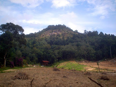

About 2 weeks ago, I had a weird dream where I entered an alternate universe via a door on top of a certain hill, one that as far as I remember I've never stepped foot on. And I've stepped foot on many summits... There's just one clue given... The hill lies near Tanjung Olak...

Now, I've never been to Tanjung Olak but I know there's such a place by that name in Muar. Suffice to say, it gave me the strong impetus to return to Muar for the Islamic Aidil Adha celebration. Otherwise I could have celebrated it elsewhere as there's part of me that wanted to head for Kelantan or Terengganu to start a new session of adventure.

To cut a long story short, after visiting Kota Buruk, me and my brother immediately head for Tanjung Olak about 10km away, on the small road which leads to a dead end. The problem is I don't see any hill there, so how?

After loitering for a while I decided to head back towards Jorak. From there I plan to go to Pagoh to visit another place. Just a kilometre or so after heading back from the said Tanjung Olak, I saw a hill that looks exactly like that in my dream! Except it is located quite a distance away, at least that's what it looks like from there...

Luckily I stopped at a stall in Jorak to have brunch and met a rather knowledgeable elder person. Somehow we hit on and I told him about the dream...

Then he told me the Tanjung Olak I went just now, the Tanjung Olak that appears in current maps was not the original Tanjung Olak. In fact the real (or old) Tanjung Olak lies near a hill just like the one I saw in my dream! And according to him there are some mystical legends associated to that place...

The problem is how to get there... Apparently there's some inland routes through some rural villages and plantations but the roads might not be good enough to give way for my brother's car and its low floor. Besides there's just too much junctions and we could get lost. So he told me to get to the main road from Bukit Pasir to Pagoh and look for the junction to a quarry. That's how I get to the hill shown in the picture above...
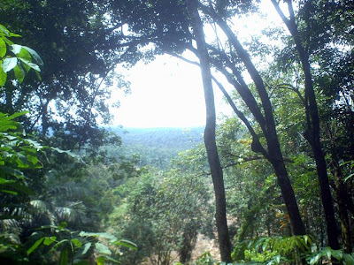

Now, I'm positive I've seen this hill in another dream. It's just I'm not sure is it the same hill as the one in the dream which gives the name Tanjung Olak because the one in the recent dream looks like it had a slightly sharper summit. Then again perhaps that is the view from another angle?

So I decided to make a quick climb. If there is another hill it should not be so far off... It should be visible from up this hill I reasoned...
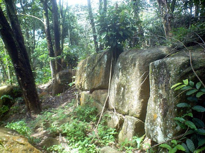

I went on leaving my brother waiting in the car down below. I went on until the foliage got so thick and blocked the path up... A path which I could have gone through but had to endure some mess to my clothings...

Then again I've been gone for a while and my poor brother down there, sitting in the car with the hot sun shining might not be so happy. So I decided to climb down...

Do I get the right hill? I hope so... At least I've tried...

Now, there could just be another hill around but I surely can't see through the plants and foliages... The only way to make sure is to climb all the way up where it is clearer but the hill is quite high and the path blocked while I sure can't expect my brother to continue waiting. So I left the place hoping that those who matters know I've tried... Don't ask who those people are OK...
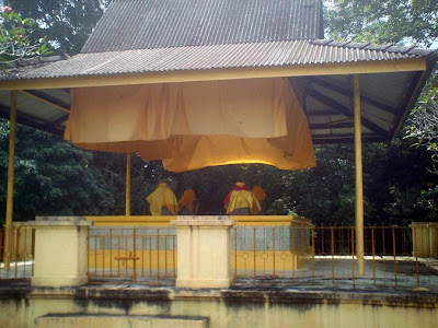

Next, we went to Kampung Raja, Pagoh more than 10km further and visited the tomb of Sultan Alauddin Riayat Shah of Melaka (ruled in the 1480s AD or so), the only surviving tomb of a Melaka Sultan... The last time I was here was perhaps half a year ago...
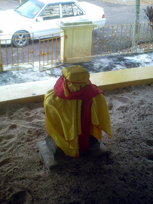

This time I decided to bring my Selempang Merah (literally translated as red sash) along... Again don't ask me what is this thing. Those who know should know what it signifies...

This time I felt like wrapping the red sash in a position known as the lam jalallah (like a variation of the Arabic letter lam) at the head gravestone of the Sultan... I don't know why, I just did...

After doing my obligatory prayers at the mosque besides the tomb, we left and head back for my parents' place in Kampung Temiang...
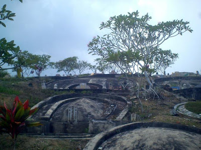

On the way, we passed through Bukit Pasir and saw this huge Chinese cemetery area covering the hill at the small town... Ah... There is enough high clearing here for me to clarify whether I made up the hill at Tanjung Olak (the old Tanjung Olak that is) or not...


From on top that hill, one could get a good view of the legendary Gunung Ledang or Mount Ophir some 30km away heading north-east...


A look towards the east shows these hills... Then I realised the one in the middle was the one I climbed up where else there's another hill albeit a much smaller one just a bit up to the north.

Now I remember... The sign-board on the main road leading to the hills said the quarry is a 4.5km inland where else we went in for only about 1-2km or so... I mean we could have gone further inside but the road, frequented by many heavy vehicles were such in a bad shape that I could see my brother's face squint whenever he had to negotiate a hole... And there's many of them.. That's why I decided not to get any further and thus just went up the hill as seen in the first picture.

So did I went up the right hill I saw in the recent dream, the one with the name Tanjung Olak attached to it? Looks like I missed that one... But I know for sure, the one I climbed up was shown in another dream, a much earlier one and that is it itself revealing. And I've tried what I could within the limited time and resources available then...

Perhaps, I will make another visit and climb the right hill. Perhaps... Meanwhile I hope God is pleased that I've continued doing my little bit to understand the things that I should given the certain type and lineage of blood that flow through my veins. Given this posting which is a way for me to let go of what happened, hopefully more pieces of the jigsaw puzzle that is my purpose in life will be made apparent soon enough. That's it! ... :]

The legendary Kota Buruk (ruined fort) of Muar...

Greeting dear readers. I'm currently in Mersing following a spontaneous round trip around the state of Johor after celebrating the Islamic festive day of Aidil Adha at my parents' place in Muar. Suffice to say, after that I spent a night in Batu Pahat, then Pontian, Johor Bahru, Kota Tinggi and last night here. Afterwards, I'm slated to go somewhere else, that is God willing...
OK... After more than a week not making any postings here, let's get down straight to business ya. Here is something really worth telling... A piece of old history in Muar using pictures taken last week...


Just a few kilometres away from my parents' place in Kampung Temiang (5km away from main town Muar), on the way to Pagoh one can see the signboard above... Actually the signboard was only recently erected, perhaps at most two months ago. So many might not know about...

I remember going pass this road many times whenever on holiday in Muar... After all, it lies on the shortcut route from Kampung Temiang to Bakri Batu 6 where lies the grave of my dearly departed brother who passed away in a road accident 5 years ago. But I first noticed this signboard just about a month ago. And that's when I promised myself to go and see what it's all about...


Now, I've never been to this part of Muar my whole life. Thank God one of my brothers was around, so I had the benefit of his car... After all, I have none and have been practically travelling on public transport for the last 5 years, that is after my trusty big bike broke down and I haven't got the money to repair it... Until now that is. Still the bike wasn't repaired and that is another story.

Suffice to say, we had to enter a plantation and made a few wrong turns before finally getting it right... Thank God... Otherwise I don't want to burden my brother too much especially since his car got such a low floor that many times it grazed the stones and dirts on the rather difficult plantation roads...


So here I am, finally at the site of Kota Buruk which could be literally translated as the ruined fort...


So what is this all about? Is it worth all the trouble? Well I can assure you that if you like old Malay history than this place is worth all the effort.

Now, I'm just too lazy to explain everything here... So I took this picture of the information available where you can have a look at it yourself. What you can do is right-click at the picture and save it inside your computer. Then you can open it and blow the size or make any adjustment necessary to make the text clear enough for reading.

OK... Perhaps I should give my 2 cents worth of explanation alongside. Remember the Malay Sultanate of Melaka said to have been opened by a certain royalty known by Western historians as Parameswara some 600 years ago? Well, before he opened up Melaka, he tried to open a new state in Muar, in a place which later became known as Biawak Busuk (literally translated as rotten monitor lizards). This is because the place was infested with many such creatures which had to be killed but more came along, and on and on... The piles of dead carcasses made it unbearable to stay on and thus Parameswara had to find another place to start a new state.

Oh... Let me be frank. I never really like the term Parameswara. Let's call him by his proper Malay name and honorific ya... Let's call him Sultan or King Iskandar.

After leaving Biawak Busuk, he went a bit upriver and built a new fort to start another state and community centre. The legends goes that all is fine until the next morning. Apparently for no known reason, the fort became ruined... Thus the name name Kota Buruk... Kota (fort) Buruk (ruined) and here is the site of the fort...

Now some believed the fort got ruined because of termite attack. Nevertheless, it is possible that if there was no such problem and Sultan Iskandar stayed one, the state of Melaka could have been started here and the whole Melaka empire story could have taken a different turn!


Next to it lies some foliage and a clearing...


As it is, the site is located next to the rather mighty and full of history Muar river...


Among the foliage lies a rather gargantuan tree...

The way the branches spreads out and its sheer size reminds me of a similar singular tree at Pulau Besar, Melaka... On the way up on top it's highest peak which leads to the legendary and mystical (and myhtical too) Batu Belah... Do have a look at Batu Belah (split stone) of Pulau Besar, Melaka

Near the clearing lies another curious object...


It is the tomb of someone of stature as denoted by the gravestone known as Batu Aceh or Aceh gravestone, normally used for someone of very high status... The yellow clothes and colour abound signify royalty... Too bad there's no notice saying who it belongs to...


Next to the grave lies this small tree with bits of yellow clothes and some pots and things normally used for worshipping... That is, the kind of worshipping condemned in Islam but practiced by people who believe in magical powers and getting favours from the unseen, even unholy creatures!


And not far away is another grave, also with gravestones covered in yellow clothing signifying royalty... Perhaps of lesser status. That's all ya. Cheers! :]

Friday, December 21, 2007

On top of Ampang!

OK... While I'm still on the Net and have streak in me to continue posting, let me just pick up from where we left off at Fooling around the Semenyih Dam... .
And so after leaving the lake and taking the road straight to Ulu Langat, we then took the road which connects that small town straight to Ampang. Underwise one would have to get to Cheras first before taking the Middle Ring Road pass Pandan Indah to Ampang.
Apparently, the friend and his wife who were travelling with me on this particular trip (oh, we went up the Gabai waterfalls before going to the Semenyih Dam) don't even know that the road connecting Ulu Langat to Ampang exist. Actually it have existed for years and since 'discovering' it about 10 years ago, I would make a trip every now and then through the road.
For one, it is a shortcut to get to the Ulu Langat area from mid Kuala Lumpur... If memory serves me right, Ulu Langat is only 5 to 7km from Ampang through this route... Otherwise (through Cheras that is) it would take up to (or more than) 20km! But the best thing is, it is very scenic. Wait until you see the view of the Klang Valley available from the route!

Anyway, the road from Ulu Langat to Ampang (and vice versa) have to pass a range of hills which forms part of the Peninsular's main range of mountains, better known as the Banjaran Titiwangsa. At the highest part of the route, on top of a hill, lies a rest place developed by the state authorities...


As my friend and his wife have never been here, we might as well stop. Besides, the last time I went here myself was probably over a year ago. But first order of things, we were pretty famished. It's time to head for the restaurant...

The restaurant itself offers a nice view of things. But my cheap digital camera couldn't catch it properly due to the contrasting lights...


So I had to go the edge of the verandah and snap this picture. There! Magnificent view of Kuala Lumpur isn't it? There's not much place around where you can get this sort of view!


After lunch, we went up the stairs seen in the first picture. Decided to snap the rooftop of the restaurant and the adjacent buildings... Seen in the background is the 5,000 feet-high or so Gunung (mount) Nuang, the highest peak in the state of Selangor...


At the highest part of the hill lies a viewing tower open to all and sundry...


At its foot there's a few seats apparently very popular for couples trying to 'discover' each other, hehe! :]


As always, a trip like this is not complete without going up the tower. Not that you have to pay anything...


Ah... Now, a much better view of KL...


And this is how the restaurant and the buildings beside look from the tower... The design of the rooftop gives the view a certain flair...


The view available from the highest level of the tower. Enough ya! Cheers...