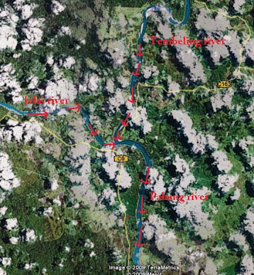
 There are two main routes to get to the East Coast from the Klang Valley. Both pass through the Karak Highway but starts to fork near Bentong, Pahang. That's where some traffic went straight east to the coastal town of Kuantan before heading northwards to the state of Terengganu. Those heading for Kelantan would take a north-east route which passes through Raub. That's the route I took before deciding to make a diversion to an idyllic place called Kuala Medang...
 From Raub one could take the usual busy route pass Kuala Lipis to Gua Musang, the nearest Kelantan town. An alternative route passes throuh Batu Talam on to Sungai Koyan where a right turn would bring one back to the Kuala Lipis-Gua Musang main road. In happened that the second route passes near my late grandma's house. After reaching Sungai Koyan, instead to turning right I felt like going to Kuala Medang as it is only another 10 km or so up north...
 The last time I was in Kuala Medang was perhaps some 2 years earlier or more. Being almost 60 km north or Raub on a quite route which leads to a dead end off the mountains, it is not really a destination of choice for most people. But I am not most people. I love to go off the beaten path. So what is available there? The bridge ahead should give a clue...
 Look... the locals like to hang out here...
 For beneath the bridge lies the river Jelai, one of the most important river in Pahang!
 Likewise we also made a stop. Oh, I forgot to tell, my wife was also around. And in tow was our baby who was then still in mummy's tummy, almost 8 months old inside that is...
 A look to the east shows the river bending north-east. For the record it goes all the way to Kuala Lipis before joining the mightier Pahang river off Jerantut, the longest river in Peninsular Malaysia. A check using Google Earth shows the Jelai river weaving in an out the landscape for some 40 km to reach Kuala Lipis and another 50 km before reaching the area of Kuala Tembeling where the Tembeling river flows into it. For the record, the Tembeling river is the main riverine route to the National Park where lies 7,000-feet-plus-high Mount Tahan, the tallest peak in the Peninsular.
 Anyway here's a look at the village of Kuala Medang from the highest point off the bridge across the river Jelai...
 Another look to the west. For the record upstream river Jelai is made of a number of rivers originating from the main mountain range of Banjaran Titiwangsa. In fact it weaves up for more than 70 km to the resort area of Cameron Highlands. I understand the waters at the famous Robinson Falls at Tanah Rata, Cameron Highlands pour on into this river...


No comments:
Post a Comment